Modèles > Géographie >

World Countries Template

World Countries Template

Collect and organize information about the geographical features of a country/state/county.

Keywords: Geography, country features, learning countries, geographical features

Learn countries of the world

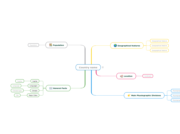
Learn countries of the world by completing this template with characteristics about each country. For example, think about geographical features like the length of the rivers, the height of the mountains, what are the neighbors, etc.

Also, after you choose the country you are going to analyze, respond to questions like the ones below:

On which continent is this country located?

What are the Main Physiographic Divisions of this country?

What are the languages spoken in this country?

What is the climate of this country?

What are the major cities of this country?

What is the population of this country?

Country name

Keywords: countries, states, geography, cities, capital city, climate, physiographic divisions


Write the name of the country/state/county you are going to analyze. Then add a representative image.

General Facts

Think about this general facts about Country name.

Major Cities
City

A major city from Country name

Climate
Climate type

A climate type from Country name

Languages
Language

A language spoken in Country name

Capital

The capital of Country name

Population

What is the population of Country name?

The number of people living in Country name

Main Physiographic Divisions

Physiographic regions of the world are a way of defining Earth's landforms into distinct regions.

What are the Physiographic regions of Country name?

Psysiographic Division

Location

What is the continent where Country name is located?

Continent

Geographical features

Add geographical features of Country name. They can be related to the length of the rivers, the height of the mountains, what are the neighbours etc.
Geographical feature

Add a geographical feature. It can be related to the length of the rivers, the height of the mountains, what are the neighbours etc.
World Countries Template

Pourquoi utiliser un modèle de carte mentale Mindomo?

Les cartes mentales vous aident à faire un brainstorming, à établir des relations entre les concepts, à organiser et à générer des idées.

Cependant, les modèles de cartes mentales offrent un moyen plus facile de commencer, car il s'agit de cadres qui contiennent des informations sur un sujet spécifique avec des instructions d'orientation. Par essence, les modèles de cartes mentales assurent la structure qui combine tous les éléments d'un sujet spécifique et servent de point de départ à votre carte mentale personnelle. Ils constituent une ressource qui offre une solution pratique pour créer une carte heuristique sur un sujet particulier, que ce soit dans le domaine des affaires ou de l'éducation.

Mindomo vous propose des modèles de cartes mentales intelligentes qui vous permettent de fonctionner et de penser sans effort.

Un modèle a plusieurs fonctionnalités:

Thèmes descriptifs

Sujets avec texte d'arrière-plan

Branche par défaut

Suppression des données du modèle

Vous pouvez choisir parmi une variété de modèles de cartes heuristiques provenant des comptes professionnels ou éducatifs de Mindomo, ou vous pouvez créer vos propres modèles de cartes heuristiques à partir de zéro. Toute carte heuristique peut être transformée en modèle de carte heuristique en ajoutant des notes d'orientation à l'un de ses sujets.